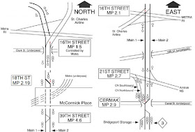
In a move that could only make sense as part of some nefarious plan to cripple Amtrak service, Canadian National has single tracked a critical portion of its connecting line between the former Illinois Central main line and it's Chicago area distributor that runs west to Joliet on the former Chicago and Alton alignment. Specifically the mile or so long segment between the two major passenger crossings at 16th St and 21st St, the former controlled by a famous METRA interlocking tower and the second by Amtrak's Chicago terminal train directors.
As you can see in the above diagram CN has cut Main Track 1 between a new 18TH ST interlocking and the existing CERMACK interlocking. The method of the cut will create bottlenecks for Illini Service Amtrak trains on and off the St Charles Air Line from downstate and Lincoln Service trains entering and exiting the Heritage Corridor at CERMACK due to Conrail style interlockings that eliminate any sort of parallel operation. Why would they do such a thing?
The answer is diamonds, and not the kind that makes one wealthy. Elimination of Main Track #1 will also eliminate 5 diamonds between both interlockings. For those of you who don't know, main line diamonds are expensive maintenance items that also require fairly periodic replacement.
As we can see from this photo at 21st St, the small signs seem to indicate that the diamonds are the maintenance responsibility of CN. The bottleneck will be felt as freight white periods at both crossings cause CN traffic to back up along the line and this will now preclude Amtrak service from being able to sneak by. Perhaps that is the ultimate point. "Unavoidable" delays may force the State's hand in funding alternatives to the diamond crossings like an overpass at 16th St and the Grand Crossing connector on the NS Chicago Line south of the city. The real loser is the 16th St tower which will loose a substantial number of its remaining active levers :-(


I think your left map direction arrow is wrong. Clark street is North/South at 16th St.
ReplyDeletehttps://www.google.com/maps/place/S+Clark+St+%26+W+16th+St,+Chicago,+IL+60616/@41.859876,-87.6327025,16z/data=!4m5!3m4!1s0x880e2c88ce456647:0xe7b3f3fa00d8070e!8m2!3d41.8601157!4d-87.6302563
The map refers to railroad direction. The IC Line is North-South to some point in that area.
Delete